


Rotational landslides

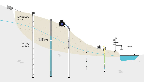
A rotational landslide occurs when a mass of soil or weak rock moves downwards and outwards along a curved slip surface. As the material rotates, tension cracks may open near the head of the slide, the upper section may tilt backwards, and the toe may bulge or move forwards.
Because movement can develop below the surface before obvious changes appear at ground level, visual inspection alone cannot provide a complete picture of slope behaviour. Reliable monitoring is needed to locate the active shear surface, measure the rate and direction of movement, and understand the groundwater conditions influencing stability.
Sisgeo provides geotechnical instrumentation for rotational landslide monitoring. By combining subsurface displacement, surface deformation and pore-water pressure measurements with automated data acquisition, project teams can identify changing conditions, assess whether movement is stable or accelerating, and make informed risk-management decisions.
What is rotational landslide monitoring?
Rotational landslide monitoring is the systematic measurement of movement within a slope and at its surface, together with groundwater conditions and other factors that affect stability. It is used to establish the geometry and depth of the active slide, track changes over time and provide evidence for risk assessment, stabilisation and early-warning decisions.
Rotational sliding, sometimes called rotational slumping, is most common in relatively uniform or layered materials such as clay, silt, weathered rock and weak sedimentary deposits. The curved failure surface distinguishes it from translational sliding, where material moves along a flatter plane with less rotation.
A monitoring system may combine borehole instruments that measure displacement at depth with surface instruments that record cracking, settlement and tilt. Piezometers add information about pore-water pressure, which can reduce the effective strength of the slope and contribute to renewed movement following prolonged rainfall, drainage problems or changes in site conditions.
Together, these measurements show whether different parts of the landslide are moving, how quickly displacement is developing and whether movement corresponds with changes in groundwater pressure or nearby works.
Why is rotational landslide monitoring important?
Rotational landslides can threaten roads, railways, buildings, utilities and communities above or below a slope. Even slow movement can damage foundations and buried services, while faster acceleration can create an immediate safety risk.
A well-designed rotational landslide monitoring system helps engineers:
- Locate the depth and extent of the active shear surface.
- Measure the direction, magnitude and rate of subsurface movement.
- Identify backward rotation, settlement and lateral movement at the surface.
- Track pore-water pressure and groundwater response.
- Measure the opening or closing of tension cracks.
- Relate changes in slope behaviour to rainfall, excavation, loading or drainage works.
- Set project-specific thresholds and identify adverse trends early.
- Assess whether drainage, retaining structures or other stabilisation measures are working as intended.
Continuous or frequent monitoring is particularly valuable where the rate of movement can change quickly or where a slope protects critical infrastructure. Reliable trend data supports better-timed investigations and interventions while reducing reliance on isolated manual observations.
Key instruments for rotational landslide monitoring
The most appropriate instrument combination depends on the depth and geometry of the landslide, the expected rate of movement, ground conditions and the assets at risk. Sisgeo systems can support periodic manual surveys, automated monitoring or a combination of both.
Inclinometer casings and portable probes – installed in boreholes allow engineers to measure horizontal displacement through the slope profile. Repeat surveys can identify the depth of concentrated movement and help define the active slip surface.
IPI in-place inclinometers – IPI chains provide frequent or continuous measurements of lateral displacement at selected depths. Connected to an automated acquisition system, they can reveal changes in movement rate and support threshold-based alerts on active or high-risk slopes.
Piezometers – measure pore-water pressure within soil or rock. Comparing pressure changes with displacement data helps engineers understand whether groundwater conditions are contributing to instability and whether drainage measures are effective. measure pore-water pressure within soil or rock. Comparing pressure changes with displacement data helps engineers understand whether groundwater conditions are contributing to instability and whether drainage measures are effective.
Extensometers – Borehole and surface measure changes in distance between reference points. They can be used to track deformation within the landslide mass, across suspected movement zones or between stable and moving ground.
Crackmeters and jointmeters – installed across tension cracks measure opening, closing or shearing over time. These measurements help quantify surface deformation at the crown and margins of a rotational slide..
Tiltmeters – measure changes in inclination at the ground surface or on structures affected by the landslide. They can help identify rotational movement and show how buildings, retaining structures or other assets are responding.
Sisgeo rotational landslide monitoring applications
Monitoring can support investigation, construction control, stabilisation works and long-term slope-risk management
Locating and tracking the slip surface
Inclinometer manual surveys and IPI systems help identify where movement is concentrated within the slope. This information supports ground modelling, risk assessment and the design of targeted stabilisation measures.
Measuring the rate of slope movement
Repeated or automated displacement readings show whether movement is steady, seasonal, slowing or accelerating. Engineers can use these trends to review risk levels and determine when further investigation or action is required.
Understanding groundwater influence
Piezometer data can be compared with movement records to identify relationships between pore-water pressure and slope displacement. This is particularly important where heavy rainfall, changing water levels or blocked drainage may reactivate a slide.
Monitoring cracks, settlement and surface rotation
Crackmeters, settlement systems and tiltmeters quantify visible deformation across the landslide. Surface data helps confirm how the head, body and toe are responding as movement develops.
Verifying stabilisation works
Monitoring before, during and after the installation of drainage, anchors, retaining walls or other remedial measures provides evidence of their effect on slope behaviour. Long-term data can confirm whether movement and water pressure remain within acceptable limits.
Automated monitoring and early warning
Instruments connected to Sisgeo dataloggers can deliver frequent readings and remote access to monitoring data. Project-specific thresholds can be used to flag changing displacement or pressure trends, allowing teams to review conditions promptly.
Rotational landslide monitoring through every project stage
| 1. Monitoring design and instrument supply | The geometry of the landslide, expected slip depth, ground conditions, groundwater regime and consequences of failure all influence system design. Sisgeo supplies instruments matched to the parameters and monitoring frequency required by the project. |
| 2. Baseline measurement and site characterisation | Baseline readings establish how the slope behaves before construction, seasonal change or remedial work affects it. This provides a reliable point of comparison for future data. |
| 3. Installation support and automated acquisition | Accurate monitoring depends on correct instrument location, installation and configuration. Sisgeo provides technical documentation and guidance to support reliable field performance and integration with manual or automated data-acquisition systems. |
| 4. Long-term performance monitoring | Rotational landslides may remain active or reactivate after long periods of limited movement. Durable instruments and consistent data collection help teams recognise long-term trends, maintain stabilisation measures and update risk-management plans. |
Why choose Sisgeo?
We provide dependable instrumentation and technical expertise for complex, long-term slope monitoring projects. Sisgeo supports geotechnical teams with:
- More than 30 years of geotechnical and structural monitoring experience.
- High-precision instruments designed for demanding field conditions.
- Manual and automated options for subsurface and surface monitoring.
- Integrated measurement of displacement, deformation and pore-water pressure.
- Dataloggers and remote systems that support frequent readings and threshold alerts.
- Scalable solutions designed around the geometry and risk profile of each slope.
- Technical documentation and support for projects worldwide.
Sisgeo helps engineers turn data from the ground, groundwater and affected structures into a clearer understanding of rotational landslide behaviour.
FAQs
What is a rotational landslide?
A rotational landslide is the downward and outward movement of soil or weak rock along a curved slip surface. The moving mass rotates as it travels, often creating tension cracks at the head, backward tilting in the upper section and bulging near the toe.
Is rotational slumping the same as rotational sliding?
The terms are often used to describe the same curved form of slope failure. “Slump” is commonly associated with smaller or more visually obvious rotational failures, while “rotational slide” is the broader geotechnical term.
What parameters are monitored on a rotational landslide?
Common parameters include subsurface displacement, movement rate, pore-water pressure, surface settlement, tilt and the opening or closing of tension cracks. The required measurements depend on the landslide geometry, ground conditions and level of risk.
Which instruments are used for rotational landslide monitoring?
Systems may include inclinometer casings and portable probes, IPI in-place inclinometers, piezometers, extensometers, crackmeters, tiltmeters, settlement gauges and automated dataloggers.
Can rotational landslide monitoring provide an early warning?
Automated instruments can provide frequent readings and flag when project-specific movement or pressure thresholds are exceeded. Monitoring supports early-warning decisions, but thresholds and response procedures must be defined by the responsible engineers as part of a wider risk-management plan.
Discuss a rotational landslide monitoring system with Sisgeo
Need to measure deep slope movement, pore-water pressure or the performance of stabilisation works?
Speak with Sisgeo about the ground conditions, monitoring objectives and instrumentation requirements for your rotational landslide project.